THE recent royal trip to Ireland by Prince Charles and Camilla included the capital of Donegal - Letterkenny.
Like so many other visitors to the county town of Donegal, the couple were day-trippers from the North.
Letterkenny's proud boast as the main entertainment centre of the north-west, with clubs, pubs, sessions and concerts going at full throttle the year round is well-founded.
Charles and Camilla will have encountered tourists from all over Europe returning from the Wild Atlantic Way, which begins on the Inishowen Peninsula before wending its way to Kinsale in Co. Cork.
Because Letterkenny’s other foremost attraction is as a centre to explore some of the most spectacular sights in Europe - from Malin Head to Tory Island, and from Gweedore to Slieve League.
All are within an easy drive of the town, and part of the Wild Atlantic Way.
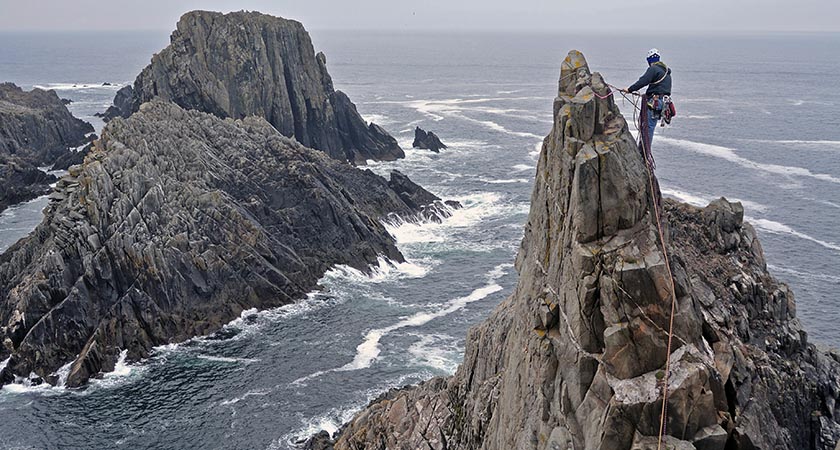 Climbing near Malin Head. Picture: Tourism Ireland
Head to head
You may have heard one of Donegal's main attractions mentioned frequently on the radio.
“There are warnings of gales in Malin, Rockall, Hebrides, Fair Isle. Low, 987, deepening rapidly, expected Malin 964 by 0700. Poor,” the broadcast will have said.
Yes, Malin Head at the top of the Inishowen Peninsula, is a place used to fairly iffy weather.
In 2011 the biggest wave ever to hit Irish shores, and one of the highest ever in Europe – 20.4 metres (67ft) high – was recorded at a buoy just north of the promontory.
Meanwhile, west of the headland is the narrow rock-cleft of Hell's Hole, where on stormy days the waves break through with eponymously hellish ferocity.
The royal party could have spent a month's holiday on the Inishowen peninsula and found something new to do every day.
The Inishowen Maritime Museum and Planetarium is located in the old coastguard station on Greencastle Harbour, overlooking one of the busiest fishing fleets in Ireland.
Its exhibition of matters nautical, botanical and ornithological is a fine account of the area.
North of the village of Malin is Banba’s Crown, with magnificent panoramic views across the ocean.
The location has a poignant significance for any emigrant - this was the spot where loved ones waved goodbye to their families and friends as they set out across the sea on the journey to a new life in America.
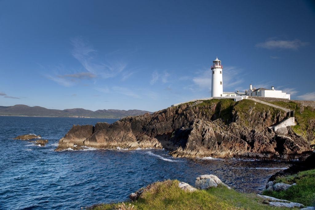 The beam team — Fanad Head Lighthouse. Picture: Tourism Ireland
The other head
The Fanad Peninsula on Lough Swilly is famous as the departure point for the Flight of the Earls in 1607.
Hugh O'Neill, earl of Tyrone, and Rory O'Donnell, earl of Tirconnell, finally admitted defeat against the invaders and quit Ireland.
They sailed from Rathmullan, and ancient, Gaelic Ireland was no more.
The Flight of the Earls Heritage Centre, housed in a 19th century fort built by the British to keep the French out, tells the whole story (00 353 74 915 8131).
The Peninsula has several ancient architectural gems.
The well-preserved Rathmullan Friary was founded in 1508 by the MacSweeney clan, who gave it to the Carmelites.
Despite being plundered regularly and having to withstand the northern coast’s lively weather, the friary was used until the 19th century.
Two miles up the coast road north of Rathmullan stands the 10th century Drumhallach cross slab, which has stone carvings of two figures sucking their thumbs – presumably a depiction of sinners contemplating their fate.
The Kildooney More portal tomb is also near Rathmullan – it’s been there for the best part of 4,000 years.
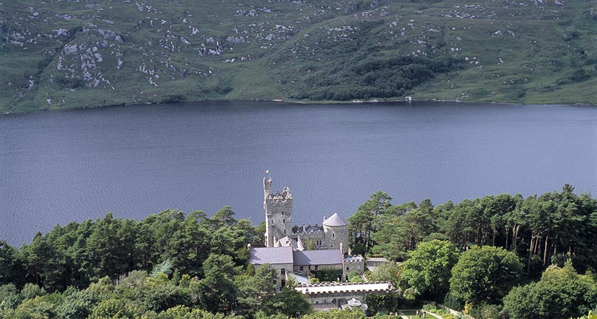 Glenveagh Castle — many celebrities have crashed here for the night. Picture: Tourism Ireland
The park
Just south of Letterkenny is Glenveagh National Park, at over 16,000 hectares, the largest of Ireland's five National Parks.
The park lies in the Derryveagh Mountains and comes fully equipped with lake shore Victorian faux castle and immaculate gardens.
Formerly an enormous private estate, the national park is made up of glens and loughs set in rugged mountains and bogland.
The superb white quartzite cone of Mount Errigal rises some 2466 ft above Dunlewy Lough and Lough Nacung.
The north-east end of the park has a gentler array of hills, deep peat bogs and the swampy valley of the Owencarrow river.
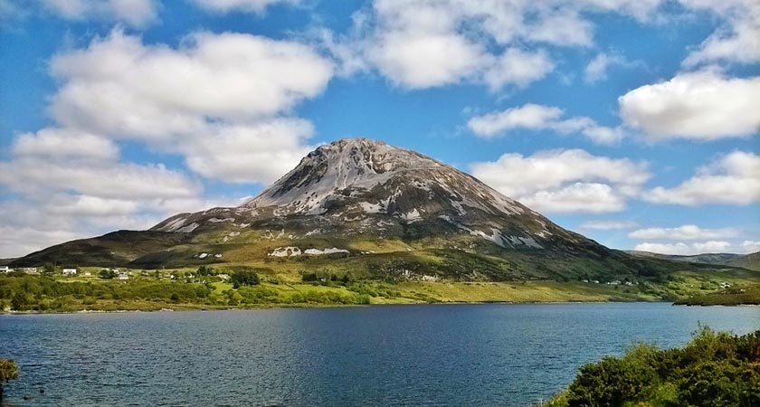 Mount Errigal. Picture: Tourism Ireland
Glenveagh offers some fine walks.
The grandeur of the original estate contrasts beautifully with the impressive natural landscape — waterfalls plummeting down sheer cliffs, mighty coniferous forests, whooper swans gliding across lakes — to provide serene, supreme beauty.
Glenveagh Castle has played host to Hollywood royalty in the past. Greta Garbo stayed here in 1968 when the place was privately owned by the flamboyant owner, Henry McIlhenny.
She was one of several Hollywood stars and celebrities from show biz and music crash here.
According to local lore — and this story does crop up elsewhere in Donegal — the area was agog in the late 1960s at the news that a famous violinist called Hughie McMenamin (or possibly Hughie Monaghan) was staying at the castle.
Turned out to be Yehudi Menuhin.
Time to head south and the dramatic Glengesh Pass with its hairpin bends, its boreens lined with fuchsia and orange montbretia, and its lavish views.
Eventually you’ll come to Ardara where the Corner House pub plays host to the best traditional sessions in Donegal.
Throughout the summer and at weekends musicians from all over the world descend on this hostelry. Hughie Minihan probably paid a visit.
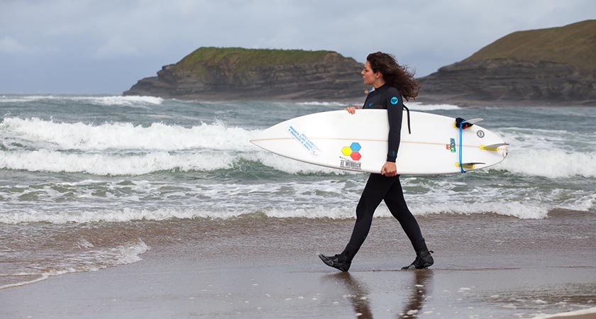 Surf's up in Donegal. Picture: Tourism Ireland
Surf’s up
Bundoran, Donegal’s most southerly town, has transformed itself in recent years.
From a low-spend centre for stag and hen parties, it has turned itself into a surfing centre, with surfers from all over the world congregating here.
Visitors from those other great surfing superpowers, Hawaii, South Africa, Australia and southern Spain regularly visit.
They may not know that beyond Aughurus Head lies the Fair Bridge and the Puffing hole — the latter an impressive rock funnel which ejects water in an impressive display — but they do know that the rollers which crash onto the shores of Donegal Bay have travelled 3,000 miles to get there.
Accordingly, they provide perfect surfing conditions with excellent sport on three beaches, each suitable for people at different levels of ability, depending on condition
If you just want to swim – or watch the surfing – Tullan Strand extends north from the town towards the River Erne and can give you one of the most bracing walks imaginable. They say that the wind stopped blowing here one day and everybody fell over.
Rossnowlagh, or the ‘Heavenly Cove' is regarded by many as the most scenic and dramatic beach in the whole of the north west.
Just 8km from Ballyshannon, the beach has fantastic views of the coastline of Donegal Bay, framed to the north by the Slieve League cliffs.
Set in a 4km crescent of golden sand with the sparkle of shimmering waves breaking on the beach, Rossknowlagh is a haven for all kinds of water sports - board sailing, surfing, water skiing, kite surfing, dingy sailing and sea-canoeing.
Despite its Atlantic aspect, the beach provides ideal safe bathing - with lifeguard patrols.
Rossnowlagh beach was one of the first places to be surfed in Ireland in the early 1960s. Surfboards and wetsuits, as well as surf lessons, are available for hire at the surf club on the seafront next to the lifeguard station.
The Finn McCool surf school has been servicing the surfers of Donegal for over 50 years.
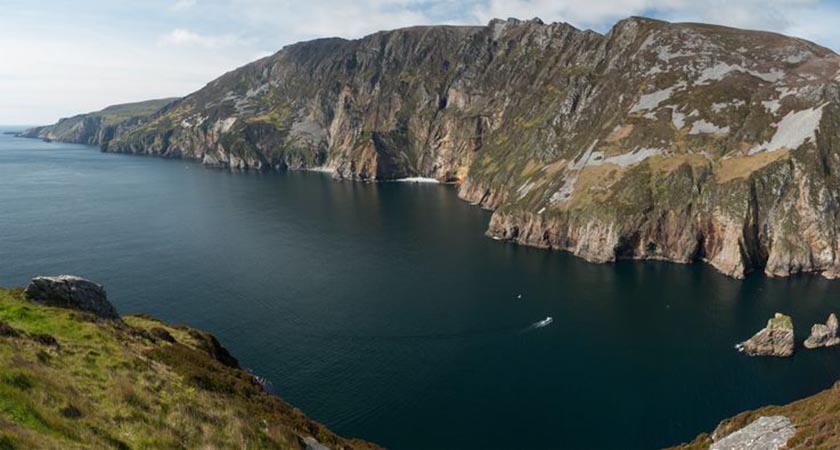 The vertiginous Slieve League Cliffs. Picture: Tourism Ireland
The Cliffs
Slieve League is where geology takes on a dizzying dimension. The Slieve League Cliffs are just outside the town of Carrick in the south west of the county, overlooking Donegal Bay.
It’s claimed they’re the highest in Europe with a sheer drop of 1,972 ft into the Atlantic, although Croaghaun on Achill disputes the title.
Both agree, however, that the Cliffs of Moher are mere child’s play by comparison. And anyway, what's a couple of hundred feet between friends, especially when a 50 mph. wind threatens to dislodge you from your vantage point.
No matter, this truly is one of the most magnificent sights anywhere.
Different hues in the rock formation - orange, red and grey, mingled with stains of various metallic ores, accumulate with washed down clays and soils to provide an impossibly colourful background to the restless Atlantic below.
You may or may not want to venture along One Man's Pass. As the AA Illustrated Road Map of Ireland says: "The cliff scenery is notable for its majestic grandeur and exquisite scenery...however it is a difficult place to negotiate, and should only be attempted by the experienced."
With a drop on one side of 1800 ft, and on the other 1000 ft, you need to have a fair head for heights to appreciate "Slieve League's awesome precipices".
Other paths, not quite so scary, traverse the area. Along these ancient byways, armies have slogged, Spanish sailors from the Armada have trudged, smugglers have carried their booty, sheep have munched their way ever onwards.
In the last century asses and ponies carried ladies to the very top of the cliffs.
Near the summit of Slieve League clearly marked out in the blanket of heather is a sign, visible for many miles, saying simply 'Tír Éire'.
This advised aircraft in the 1940s that here was a neutral country. Forts and lookout towers from the Napoleonic wars cling to the edge - and everywhere the crashing sound of the ocean and the lonely call of seabirds.
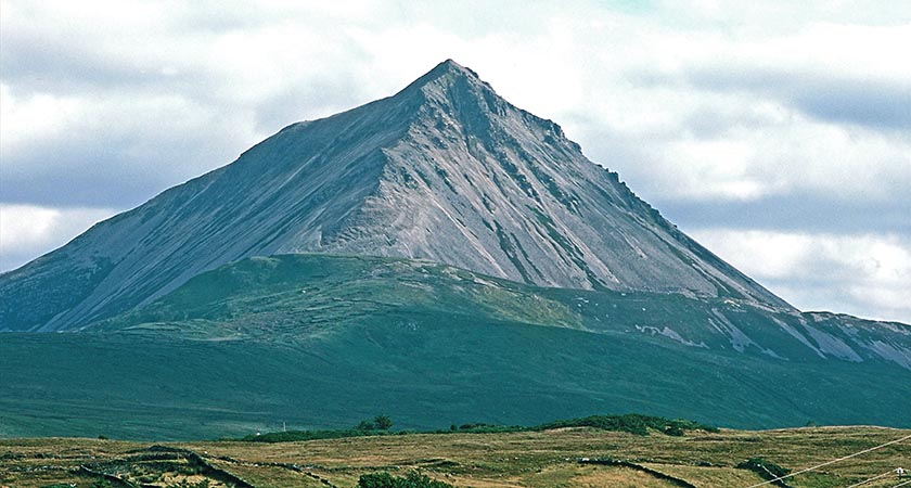 The Blue Stack Mountains — formidable looking, but provide good hiking country. Picture: Tourism Ireland
The Mountains
The Blue Stacks are amongst Ireland’s most northerly mountains, ranging roughly from Donegal Town northwards towards Letterkenny.
The highest point, Blue Stack itself – a “here I am, here I stand” sort of mountain - reaches some 2,219 ft.
Surrounded by Banagher Hill, Croaghaniwore and Lavaghmore, it overlooks dark Lough Eske.
Blue Stack stands just outside Donegal Town - famous for its 15th century castle, tweeds and traditional music pubs - and must be one of the few places in the world where you might be ensconced in a pub in the town centre and think, hmmm, I might just go and climb one of the most beautiful mountains in the entire continent.
And then just walk there; it’s only five miles away.
The Ulster Way threads through the mountains – you’ll pass impressive waterfalls, bogland filled with wild flowers, and experience simply staggering views.
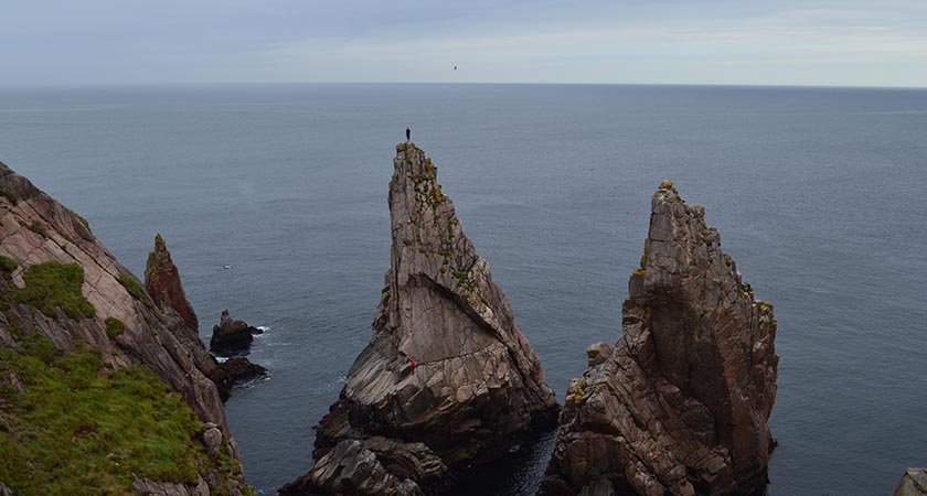 Tory Island. Picture: Tourism Ireland
The Islands
Donegal boasts two inhabited islands of its coast — Arranmore and Tory. Arranmore is closer to the mainland and is more populated; Tory island is more isolated, and altogether more eccentric.
Did I say isolated? Well, it’s nine miles from the mainland, has a ferry service seven days a week, weather permitting.
The island has its own king; it is justly famous for its school of primitive painters (founded in the 1960s by British painter Derek Hill); it boasts a Tau cross, one of only two in Ireland and with specific links to Coptic Christianity; it has its own cure for rats.
The remote fastness of this fragment of Donegal probably means it is never destined to become a major tourist destination.
But on Tory they know you've made an effort to visit, and will reward you accordingly.
They'll tell you that in days gone by late-night poitin drinkers on their way home were forced to negotiate the hazardous journey back, along a rough track, in a series of 50 yard hikes.
These were timed to coincide with the circling beam of the lighthouse as it illuminated the deepest and most dangerous potholes.
They'll tell you that story and many more, because the art of the shenachie, the ancient storyteller, is still alive and well in this isolated but friendly place.
They’ll probably tell you the one about the famous international fiddler called Hughie McMennamin visiting back in the 1960s,
If you're looking for a slice of old Ireland, some of it can still be found here in the Dún na nGall.
Paraphrasing an old saying: when it's 3am in Dublin's Temple Bar, it's still 1955 in Donegal.

